Convert GridFloat Data to XYZ with GDAL Translate
| Step | Description | Screenshot | ||||
| 1a | Obtain GridFloat Data: Step 1 | 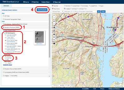 |
||||
| The primary method for downloading The National Map (TNM) raster GridFloat (3D Elevation Program (3DEP) 1- or 1/3-arc-second only) type of staged products is by using the new TNM download client (http://viewer.nationalmap.gov/basic/). Zoom to the area of interest. Select "Elevation Products (3DEP)" from the Datasets section on the left (1), then a subcategory (2) and GridFloat file format (3). Finally, click on the "Find Products" button (4) to bring up the available products. | ||||||
| 1b | Obtain GridFloat Data: Step 2 | 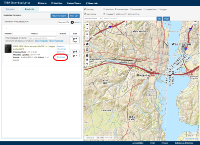 |
||||
| When the Available Products window appears, click on "Download" to download the GridFloat data in a zip file. Once downloaded, unzip the file locally, making note of the location. | ||||||
| 2 | Run the GDAL Translate Tool from the Command Line | 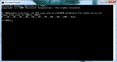 |
||||
|
The gdal_translate command requires two parameters to convert a GridFloat file. The first is the location and name of the GridFloat file to be converted. This tool will not recursively scan the sub-directories to find the data, so the path must point to the actual GridFloat file. The second parameter is the desired name and location of the XYZ output file.
Directions for using this script are presented below:
|
||||||
![]() U.S. Department of the Interior |
U.S. Geological Survey
U.S. Department of the Interior |
U.S. Geological Survey
Page Contact Information: The National Map
Page Last Modified:
